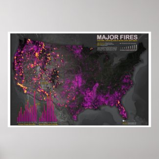
Anyways, here's the decade or so of fire data from the recent Major Fires Since 2001 map, veneered off into discrete years and clunkily flipped through in an animated GIF.
(Who ever thought the animated GIFs would make a comeback? The same people who decided plugins didn't belong in mobile, I suppose. Oh Flash, how I miss thee...)
I should also mention that the reason fires are showing up beyond the US borders is because the data source provides instances within an overfetch buffer.
Major fires since 2001. It is pretty big and may take a moment to fully load.
Or, if you rather, here they are via a not-so-small small multiple. Click for the unreasonably tall version...


The major reason wildfires are uncontrollable - and also, by the way that power outages are much more frequent and long-lasting from so many trees falling on lines - is that vegetation is dying from air pollution. That's correct, tropospheric ozone is highly toxic to plants, just like smoking is to people, and it's killing off trees at an accelerating rate as the background level around the world inexorably rises.
ReplyDeletePeople tend to think that the air pollution problem has been fixed but that's not true. Only the sulphur dioxide - the visible part of smog - has been reduced, and the high peaks of ozone. But the invisible, persistant, constant level is going up and up, and traveling to very remote forests, rendering trees unable to combat insects, disease and fungus that are meant to break down dying trees, not attack healthy specimens.
http://witsendnj.blogspot.com/2012/07/anagnorisis.html has photos and links to scientific research about what happens to plants, including annual crop yield and quality, when it absorbs the pollution we create by burning fuel and overfertilizing industrial agriculture with nitrogen.
A book on this topic can be downloaded as a free pdf here: http://www.deadtrees-dyingforests.com/pillage-plunder-pollute-llc/